Stage 2
Reference Sheet U
EVCA tools to map geographic exposure and vulnerability
Mapping is another technique that enables communities to visualize the hazards or threats, vulnerabilities and capacities in the community. Map the vulnerabilities and capacities identified in various methods. A few options are described below: general mapping, transect walk and consolidating information into the Resilience Star.
Exposure and vulnerability mapping
Tool: Mapping
Depending on the context, you can:
- Combine all the hazards or threats into one map.
- Prepare separate maps per hazard or threat.
- Overlay transparent paper onto a map of the community, with one sheet per hazard or threat.
Also map infrastructure such as health clinics, schools and houses that are vulnerable, as well as mapping out the location of resources and services that are capacities within the community (e.g., shops and businesses, clinics, schools, and markets). Maps facilitate communication and stimulate discussion. They help people to understand complex spatial relationships and allow visual comparison of information.
Geographic vulnerability (exposure): Maps can be used to identify geographic vulnerability or exposure to hazards, such as areas in a flood zone or areas most prone to virus outbreaks.
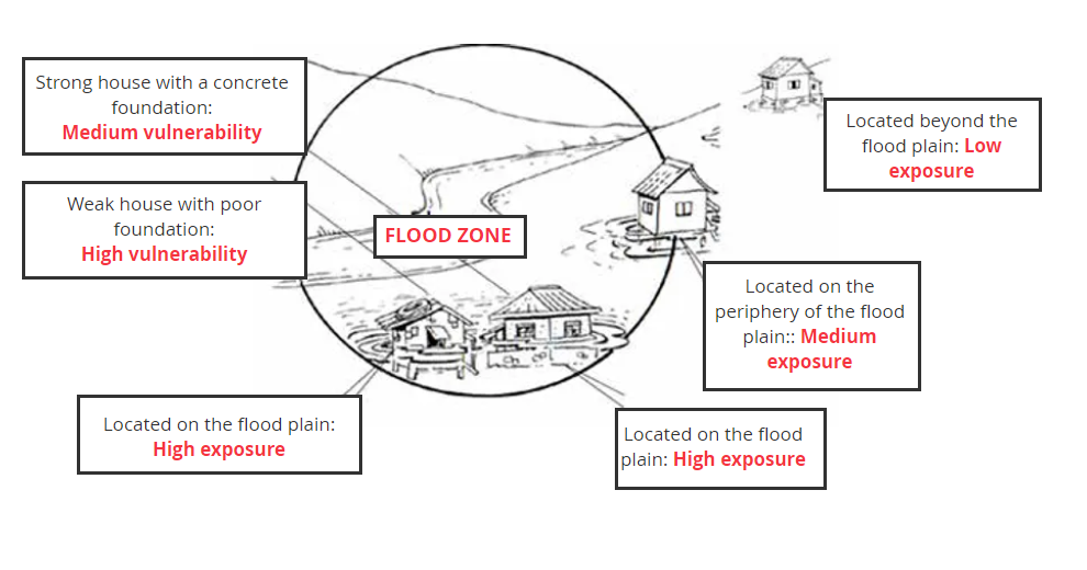
Definition: People, property, systems or other elements present in hazard zones that are subject to potential losses. As shown in the diagram, it does not matter whether the two houses are well‑built or poorly built; if they are in the same location when the waters rise, they are equally exposed to flood risk. Houses located outside of the flood zone have lower exposure.
Identify whether highly vulnerable people are living in high and medium exposed areas and, if so, where. Identify other elements that are exposed that might have been missed earlier (e.g., open water sources, location of livelihoods activities, health facilities, etc.). You can mark these using different colors.
An analysis of the different geographically vulnerable (exposed) areas is critical when compiling information on the assessment in the Resilience Star and when planning risk reduction actions. Remember, for certain hazards, interventions will be most effective if they are carried out in the highly exposed zone. For example, the highly exposed zone in the diagram above is where people live in the flood plain next to the river. Focusing risk reduction interventions in this area - such as drain construction or repair, community clean‑up of drains, and advocacy to government for stricter building codes on flood zones - can ensure that those closest to the flood plain, with highest exposure to flooding, have a reduced risk of exposure to future floods.

Transect Walk
Tool: Transect Walk
Purpose: Verify vulnerability and capacity information
A transect walk involves walking through the community to observe and discuss the daily activities, surroundings, and risks and resources. It is used to note the topography of the area, to understand interrelationships. Based on information collected in the brainstorming and mapping exercises, identify specific locations to investigate further, check whether anything was missed, and get more details.
Split into smaller groups to visit several areas of the community or get different groups to focus on a specific hazard or specific dimensions of resilience. Ideally, try to be accompanied by community members who know the area.
If some people cannot join the transect walk at the agreed time, explain the objectives to them, and ask them to provide further information. Maybe can you agree on another time to complete a second walk with community members or they can submit photos through a social media group, which highlight vulnerabilities in their community. Ensure the group involved in the transect walk is comprised of a diverse range of community people. Including wheelchair users or people with visual or hearing impairments will demonstrate the kinds of challenges around accessibility or access to services these people might face.
Consolidate information in the Resilience Star
Tool: Resilience Star (refer back to the stars completed in Step 4.5)
After completing the mapping and transect walks, add any additional information on existing vulnerability and capacities to the Resilience Star(s).
Additional information on vulnerability and capacity should be recorded in your EVCA report template.

The International Federation of Red Cross and Red Crescent Societies is the world's largest humanitarian network and is guided by seven Fundamental Principles: Humanity, Impartiality, Neutrality, Independence, Voluntary Service, Universality and Unity.
Follow IFRC
© The Global Disaster Preparedness Center 2024
