Level Three: Facilitate the assessment
At this point, you must have identified where you will do the EVCA and have taken the steps to prepare for it. You should by now know the community well through visits or secondary data and have all the materials, logistics and team ready. You should also have sent the invitation for the assessment, including date and venue, and explained the purpose to the community and stakeholders.
The assessment is structured in such a way to enable you to assist the community to identify and analyze the determinants of risk: i.e. hazards, exposure, vulnerability and coping capacity. In each step along the way, you analyze the information gathered and then synthesize it in order to identify the priority risks to be addressed. The list of the priority risks will then inform the development of a community risk reduction action plan in Level 4.
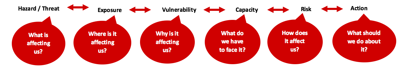
Questions to guide the assessment with the community. Source: adapted from PASSA, IFRC
Click here to read more, including a suggested sequencing of the assessment and planning process >
The below sequence suggests analysing the findings at each step and then combining the results before the risk reduction action plan is developed. This approach makes the analysis less complicated, more manageable and allows the community to participate in the analysis and synthesis of each one of the aspects more easily. Do not leave the data analysis to the end as it might be overwhelming.
Remember that the quality of your plans and projects will only be as good as the quality of the data gathering effort. In other words, the community cannot come up with a good analysis of the situation in the community and find appropriate solutions if the data and information gathered on the hazards, exposure, vulnerabilities and capacities are incomplete and/or inaccurate. Data quality relies on trust from those providing the information; therefore community members and volunteers need to understand the importance of building trust.
Data quality also depends on carefully capturing or recording the data in a way that can be later understood and used by someone not present. If the data collected are not accurate, the conclusions based on the information will not be valid. It is also vital that the right tools be chosen and applied in the proper way.
Step 4. Introduction with the community
Label
4.1 Clarify the objectives and expectations
Introduce who the EVCA team members are and let community or their representatives introduce themselves in the way they choose. Then, check if the objective of the assessment is clear to everyone in the community. Clarify that the goal is for them to create a risk profile for their community and, based on this, for them to formulate and implement a risk reduction action plan.
Clarify the expected role of the community and the roles of the different actors in the assessment and planning process. If the community has questions, take your time to address those questions and concerns before proceeding to the assessment.
Key message: Make sure you don’t create false expectations. It is important to clarify from the start whether there is funding available for the action plan or if the implementation will depend on the community’s ability to mobilize resources themselves.
Label
4.2. Explain the schedule of the assessment
Clarify how long it will take, when the assessment will take place and what the expected outcome will be. Explain practical aspects, for example if lunch or pocket money and transport will be provided during and after the assessment.
Label
4.3. Re-confirm the availability and consent of the community
Re-confirm community members’ availability — this may differ depending on gender, age, livelihood and other considerations. If certain vulnerable groups are not able to participate or be represented, ensure that members of the EVCA team consult them separately.
Confirm the community's consent to document the results of the EVCA and to take photographs/videos if needed. If you are going to work with school children, the advance written consent of parents and teachers is required and a teacher/school official must be present throughout. This point is non-negotiable. If it is not possible to obtain consent or supervision, the exercise must be cancelled and, where possible, rescheduled.
Explain available options for complaint and feedback mechanisms - see CEA Tool 15 for more guidance.
Click here to read more information and tips >
Step 5. Set the foundation
Label
5.1 Introduce, translate and adapt key concepts
It is important to introduce and discuss the key terms and translate them into the local language for better understanding. This can be done in a fun way through a story or game. This can be done in a fun way through a story or game. Limit it to a few key concepts – hazard, exposure, vulnerability, capacity and risk. Others, such as the characteristics of community resilience, can be clarified later in the process.
The aim is for the community to understand the key determinants of risk by linking the different concepts to their local expressions and world views. There may not always be an exact translation of the terms in another language, in which case a description and practical examples may be helpful.
Proposed tools: brainstorming, pictures, video, games. Optional (advanced): present risk formula.
Label
5.2 Verify and update the community profile
At this point, you should verify the general information about the community you collected through the secondary data collection during the preparation phase. This can be done through key informant interviews while the assessment is being carried out
Step 6. Hazard and exposure assessment
Label
6.1 Identify the main hazards
Purpose: for the community to identify what hazards are affecting them
Recommended tools: hazard brainstorming, historical profile, secondary/scientific data and direct observation
- 6.1.1 Brainstorming: Brainstorm all hazards community members can think of that are relevant to them.
- 6.1.2 Historical profile/disaster history: Gather basic information on what disasters have occurred when in the community. Analyze and discuss if certain hazards are increasing in frequency.
- 6.1.3 Emerging and changing hazards: Based on secondary data, present and discuss any additional hazards that affect the community but which the community has not raised. Consider in particular any emerging and changing hazards because of climate change.
- 6.1.4 Priorities the hazards: Do an initial prioritization of the most important hazards that are affecting the community, to be further analysed as part of the EVCA. The most common criteria used for this purpose are impact on the community and frequency of occurrence.
- 6.1.5 Characterize the priority hazards: Describe the nature and behavior of the priority hazards, including the cause, warning signs, lead time, period of occurrence, duration of occurrence and frequency. This is very important information to gather in order to prepare a community contingency plan in the planning phase.
Click here to read more information and tips on each step >
Label
6.2 Identify the exposure
Purpose: for the community to identify where and when hazards affect them
Recommended tools: hazard and exposure map, transect walk
- 6.2.1 Hazard and exposure mapping: Indicate the locations affected by each hazard on a spatial map and delineate high, medium and low exposure areas and the elements/features in those areas (what and who). Discuss changes of hazard locations (e.g. changes in flood zones) and possible future risk locations due to climate and environmental changes.
- 6.2.2 Transect walk/direct observation: Based on information collected in the hazard and exposure map, identify specific locations in the high and medium exposed areas to investigate further. The purpose is to ground truth your hazard and exposure map, check if you missed anything and get more details. Focus on the physical environment at this stage - i.e. cross-check the borders of the exposure areas and information on who/what is in the exposure areas. You will do another more in-depth transect walk to collect information on vulnerability in step 7.1.
Click here to read more information and tips >
Label
6.3. Synthesize hazards and exposure
Purpose: to synthesise and analyse the information collected regarding hazards and exposure
Recommended tools: ranking/scoring, focus group analysis
By reading the hazard and exposure map, analyze and list who and what is located in high, medium and low exposure areas in the below table. Include human, physical (houses, infrastructures) and natural assets. Determine if, overall, most of the ‘who and what’ are in the high, medium or low exposed areas and, on that basis, provide a score of high, moderate or low for each hazard.
The local EVCA team can summarize the information in the table ahead of time, and then bring together the community to review/endorse the summary and agree on a score for each hazard.
Click here to read more, including for a proposed summary table format >
Step 7. Vulnerability and capacity assessment
Label
7.1 Assess vulnerability
Purpose: for the community to reflect on how and why a hazard affects them.
Recommended tools: seasonal calendar; mapping; historical visualisation; problem tree; transect walk; resilience star. Optional (sectoral/thematic tools): livelihood analysis, gender co-web
7.1.1 Remind the community what vulnerability means and how it is different from capacity
7.1.2 Seasonal calendar
Ask community members to identify which hazards occur during which month(s) currently and in the past (10-30 years ago). Analyze if the timing and intensity of hazards has changed.
Add to the seasonal calendar other key events that will highlight aspects of exposure and vulnerability (e.g. periods when many health issues occur, crop and livelihood patterns, lean periods, etc). Based on the overlaps with the hazard timing, identify what and who might be exposed to a hazard (e.g. harvesting season during flood time).
7.1.3 Vulnerability brainstorming
Identify vulnerable groups in the community and specify for each group what their particular vulnerabilities are.
7.1.4 Vulnerability mapping
Going back to the hazard and exposure map, now identify whether highly vulnerable people are living in high and medium exposed areas and, if so, where.
7.1.5 Underlying causes: historical visualization
Discuss and analyze what changes in the community over time might have contributed to increasing vulnerabilities and what has provided resources and capacities that reduce risks.
7.1.6 Assess the impact and root causes: problem tree
For each of the priority hazards, ask the community to discuss what is the impact of each hazard and why is it affecting them. The aim is to find out what is causing the impact and why it might have different impacts on different vulnerable groups.
7.1.7 Transect walk
Undertake another transect walk, this time focused on social aspects/vulnerability. The purpose is to ground truth the information that has been collected on vulnerability, check if you missed anything and get more details.
7.1.8 Go deeper
If one or more of the vulnerabilities or root causes are related to a specific sector or issue and there is not enough information yet to adequately explain it, you can go deeper into the issue using additional sectoral or issue-based assessment approaches.
7.1.9 Summaries vulnerabilities
It is important now to summarise your vulnerability findings in a table according to each hazard and characteristic, and to determine what makes the community most vulnerable to each hazard. Based on the number of vulnerabilities identified and their severity, allocate a score for each characteristic (high, moderate or low) that gives an overall sense of how vulnerable the community is from the perspective of that characteristic.
Click here to read more, including for a proposed summary table format >
Label
7.2 Assess capacity
Purpose: for the community to identify what resources are available to cope with a hazard and reduce its impact
Recommended tools: secondary data, mapping, Venn diagram
7.2.1 Review secondary data on human and social capacities
Determine what skills, knowledge and capacities are available in the community.
7.2.2 Capacity brainstorming
For each hazard, brainstorm the different capacities according to each resilience characteristic. In addition, going back to the table you drew up in step 7.1.3, add a column in which you specify for each vulnerable group what their particular capacities are.
7.2.3 Capacity mapping
Looking back at the key infrastructure, buildings and services that you mapped in step 6.2.1, consider if they are capacities. For example, a hospital can only be considered a capacity if it is functional. This helps the community to identify which resources and services might help them in times of disaster or what support they might be able to get from which institution to implement their resilience action plan. Make sure to consider what capacities might not longer be available after an emergency, if they are in high or medium exposed areas.
7.2.4 Assess community organizations
Identify different organizations and institutions working in the community and use a Venn diagram to analyze their importance to, and influence on, the life of the community.
7.2.5 Summarize capacities
It is important to summarize your capacity findings in a table. Based on the number and strength of capacities identified, allocate a score for each characteristic (high, moderate or low) that gives an overall sense of how capacitated the community is from the perspective of that characteristic.
Click here to read more, including for a proposed summary table format >
Step 8. Consolidate and conclude on risk levels
Purpose: for the community to consolidate the results of the assessment and identify who and what is at high, medium and low risk
Now it is time to bring the results of exposure, vulnerability and capacity for each hazard together to start to make sense of it. As you will remember, risk is directly proportional to the hazard and level of exposure and vulnerability, and is inversely proportional to the capacity to withstand the shocks and stresses of the hazard (i.e. exposure x vulnerability / capacity).
Label
8.1 Synthesise exposure and vulnerability
In this step, the team facilitates the process for the community to consolidate analysis on exposure and vulnerability, and try to agree on an overall score per characteristic.
Click here to read more on how to synthesize exposure and vulnerability >
Label
8.2 Conclude on the risk levels
Purpose: to identify the risk levels by consolidating the analysis results of exposure, vulnerability and capacity for each hazard
Tools: "talk to the wall" exercise (ask the community to put up on a wall or table the results of the different exercises, such as the mapping and the synthesis table of vulnerability and capacity assessments. By putting the results side by side for each hazard, you can compare, triangulate and consolidate the findings)
Click here to read more on how to identify risk levels >
Label
8.3 Consolidate information on high risk elements
For each characteristic identified at high risk (and potentially medium risk), the local EVCA team should help the community consolidate them in a table (template here) with their respective exposure, vulnerability and capacity information.
The conclusion on the key risks will require a subjective judgement by the community, beyond the information that was collected.
Click here for more information, including a proposed summary table >
Label
8.4 Turn your assessment results into a baseline resilience measurement
In order to reduce risks and strengthen the resilience of a community, it is important to have a sense of the extent to which it is already resilient. Later on, you may want to know whether your risk reduction and resilience-building efforts did in fact contribute to a more resilient community.
Now that you have undertaken the EVCA, you will be able to easily turn your assessment results into a resilience measurement baseline using the EVCA report template.
Click here for more information >
Once you have a clear idea of what are the most at-risk elements in the community according to their exposure, vulnerability and capacities, you are ready to start the planning phase >>
EVCA - Level Three: Facilitate the assessment
Click below to explore Level Three and its activities in more detail.
© International Federation of the Red Cross and Red Crescent Societies 2018