CoCHAP: Tanzania
COCHAP Cities in Tanzania
Tanga and Unguja (Zanzibar) cities in Tanzania are implementing both the coastal hazard resilience and extreme heat components of the COCHAP.
Tanga is a historic port city and the capital of Tanga region. The city has a population of 393,429 in 2022. Due to close proximity to the equator and the warm Indian Ocean, the city experiences tropical climatic conditions similar to all Tanzanian coastal cities. The city experiences hot and humid weather throughout much of the year and has a tropical wet and dry climate. Annual rainfall is approximately 1,290 mm (51 in), and in a normal year there are two rainy seasons: "the long rains" in April and May and "the short rains" in November and December.
Tanga is also an important railroad terminus, connecting much of the northern Tanzanian interior with the sea. Tanga is linked to the African Great Lakes region and the Tanzanian economic capital of Dar es Salaam. The city is served by Tanga Airport.The harbour and surrounding is the centre of life in Tanga. It has several markets in several neighbourhoods.Tanga Cement is one of the major industries.
Unguja is the island of the Zanzibar Archipelago that has the most developed tourism industry. This accounts for a substantial part of Unguja's economy. Agriculture (including the production of spices such as cloves) and fishing are other relevant activities. As of the 2012 census, the total population of Unguja was 896,721, mostly concentrated in the Zanzibar urban region.The main settlement on the island is Zanzibar City, which serves as a capital for Zanzibar and which includes the renowned historical city of Stone Town as well as other populated areas such as Michenzani.
Progress and Impact
As of August 2024, we completed the following Project Activities
City-Wide Risk Assessment (CWRA)
- City-wide Risk Assessment Reports for Tanga and Unguja cities were finalized after incorporating the feedback received from municipality and other stakeholders
- The CWRA process was strengthened and enhanced through the Enhanced Vulnerability and Capacity Assessments (EVCA) in ten wards for each city (Tanga and Unguja) and the information from the GIS mapping of cities was incorporated. An intern hired through the Climate Centre also provided additional risk analysis for the city of Unguja.
Co-designing Solutions Workshop

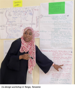
- The first co-design workshop was organized in the city of Tanga in June aimed at validating the outcome of the CWRA and prioritizing city resilience solutions based on human-centered design principles. The team is working on documenting the ideas and solutions to be submitted for matching grants.
Heat Awareness Campaign and Heat Risk Perception Study
- TRCS prepared a heat awareness campaign strategy that was developed for Tanga providing clear guidance on who is targeted, when, where and how. This strategy will be further tested in November following the commencement of the heat season.
- Furthermore, TRCS organized a heat awareness campaign in both cities (Tanga and Unguja) and developed communications materials for different target groups e.g. parents, street vendors and small businesses and tourists. The heat protection messages were delivered through social media, public displays and performances conducted by local youth artists.
Climate Context
Tanzania is one of the largest countries in East Africa, with diverse topography. Most of the population lives in rural areas, which is threatened by increasing temperatures, longer dry spells, and intense rain events.
Much of the population also depends on coastal and inland fisheries, which are vulnerable to sedimentation as well as warming ocean and freshwater temperatures.
Despite abundant water resources, Tanzania experiences spatial and temporal water scarcity, which will be exacerbated by climate impacts on the country's nine major river basins and the continent's three largest lakes.
Urban settlements poor infrastructure increases vulnerabilities to flooding and heat extremes.
Rising temperatures, longer dry spells, more intense heavy rainfall and sea level rise make Tanzania the 26th most vulnerable country to climate risks.
Current population of 56 million is expected to more than double (130 million) by 2050.
32% of the population lives in urban areas, and 75 percent of that population lives in informal settlements that are
increasingly at risk from water scarcity, flooding, and heat extremes.
Livelihoods and food supply depend on coastal and inland fisheries, which are increasingly threatened by warming ocean and freshwater temperatures, and sedimentation after heavy rains.
Sea level rise is putting coastal infrastructure, coastal populations (about 25 % of the total population), and coastal ecosystems at risk of inundation, salinization and storm surge.
Resources:
WB Climate Change Knowledge Portal/Tanzania
USAID Climate Risk Profile: Tanzania
Resources
