CoCHAP: Honduras
COCHAP Cities in Honduras
Choluteca and Nacaome cities in Honduras are implementing both the coastal hazard resilience and extreme heat components of the COCHAP and San Lorenzo city is focusing on coastal hazards.
Choluteca is a municipality and the capital city of the Honduran department of the same name. Situated in southern Honduras between El Salvador and Nicaragua, the city is generally considered the regional centre of southern Honduras and is a major transit point on the Pan-American Highway. Choluteca's population of 99,980 (2023 projection) makes it the seventh largest city in the country.
Nacaome, is the capital city of the Valle department of Honduras and the municipal seat of Nacaome Municipality. It is a manufacturing and commercial center located on the banks of the Nacaome River. As of 2013 Honduras census, Nacaome municipality had a population of 57,345. Nacaome was affected by Hurricane Stan in October 2005.
San Lorenzo is a city, with a population of 35,560 (2023 projections) and a municipality in the department of Valle.It has become one of the most developed cities in southern Honduras. Its economy is based around the seafood industry (shrimp), tourism and agriculture (watermelon, melon and other fruits).
Progress and Impact
In Honduras, (as of August 2024), we completed the following Project activities:
City-Wide Risk Assessment (CWRA)
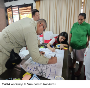
- City-wide Risk Assessment Reports focusing on heat are completed for the cities of Nacaome and Choluteca. A new CWRA workshop was organised in San Lorenzo to strengthen the process with a focus on coastal hazards at the end of July.
Heat Awareness Campaign and Heat Action Day
- Heat Communication Strategy was finalized and preparations for the heat campaign continued. As a first activity in the implementation of the pilot communication strategy, a talk on climate change and heat waves was given to seventh graders in a school.
- Heat EWS assessment has been continued in partnership with the local university and COPECO (National Disaster Management agency).
- Environmental cleaning campaigns of the mangroves in San Lorenzo were done with the support of the Ministry of Education and Ministry of Health. Follow-up of the implementation of social micro projects, through the delivery of a batch of cashew plants for the reforestation of green areas in the city of Choluteca.
- Health fairs to raise awareness about the impacts of heat on health were organized in collaboration with the Ministry of Health in the cities of Nacaome and Choluteca.
- The urban tree planting micro-project in Choluteca was completed.
Capacity building
- Field visits from Climate Center and HQ AMCROSS took place in the last week of July and first days of august, with some specific activities related to update the induction/onboarding of new staff members of project
- Urban Resilience Workshop in coordination with the Southern Chamber of Commerce and Industry
Heat Perception Study
- The instruments for the survey, interviews and focal groups were reviewed internally and validated with the consultant. The questions for the survey and interviews will be built by her team using Kobo.
Climate Context
Honduras is one of the poorest countries in the Western Hemisphere and is vulnerable to climate change due to its high exposure to climate-related hazards (hurricanes, tropical storms, floods, droughts, landslides) that devastate crops and critical infrastructure.
Honduras has a mountainous interior that creates two distinct regions with lowland coastal areas on each side.
High exposure to extreme weather events is the country's primary source of climate vulnerability, as tropical storms and hurricanes destroy key infrastructure and threaten human life and wellbeing.
Additional stressors such as reduced rainfall and higher temperatures negatively impact the agriculture sector, increase risks of water scarcity, and may inhibit hydropower plant expansion.
Honduras' coastal ecosystems and fisheries are vulnerable to warming temperatures, compounded by overfishing and environmental degradation.
Resources:
WB Climate Knowledge Portal/Honduras
USAID Climate Risk Profile: Honduras
Secondary:
Extreme Heat in Central and South America
https://preparecenter.org/resource/flood-resilience-alliance-honduras-country-briefing/
Resources